

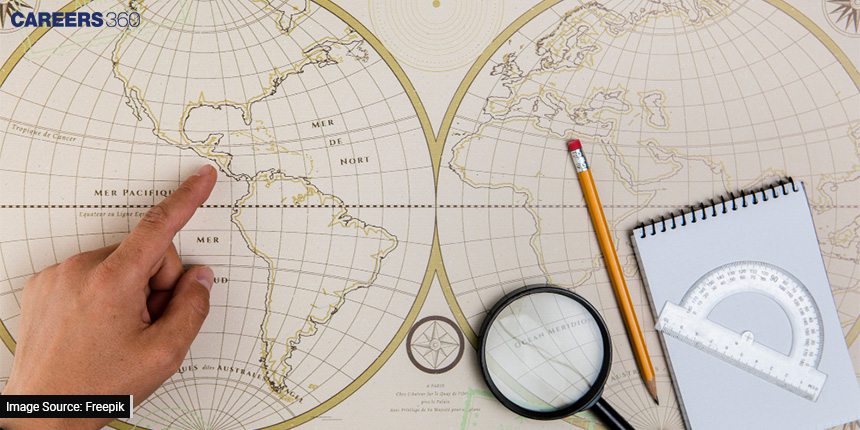
Sailing The High Seas: How Trigonometry Helps In Navigation
The story of marine exploration and navigation is one of human creativity, tenacity, and scientific discovery. Mariners have been embarking on dangerous voyages over huge oceans for millennia, guided only by the stars, the sun, and crude tools. They used trigonometry, a part of mathematics that deals with the characteristics of angles and triangles, to make decisions about where to go, how to get there, and how to get out safely.
In this article, we will discuss trigonometry in navigation, tracing its historical origins, analysing the mathematical foundations that support it, and revealing its significant effect on marine exploration and charting.
Also check - Quick And Easy Understanding Of Trigonometry For Class 10
Historical Roots Of Navigation
Navigation, the art and science of finding one's way across vast expanses of land and sea, has deep historical roots.
Ancient Navigational Methods
The art of navigation has ancient origins, dating back thousands of years. Long before the advent of modern instruments, mariners relied on observational techniques and rudimentary tools to navigate the high seas. One of the earliest methods involved celestial observations, where sailors used the positions of celestial bodies such as stars, the sun, and the moon to determine their direction and latitude.
Logbooks and Dead Reckoning
Mariners kept meticulous logbooks or ship logs to record their daily movement at sea prior to the development of more advanced systems, such as trigonometry-based navigation. These records recorded crucial details on the distances covered, the currents that prevailed, the wind patterns, the dangers that were faced, and any land or other vessels that were sighted. These records allowed sailors to "dead reckon" their locations, calculating their present location based on their last known position, course, and speed, even if precise precision was sometimes unattainable.
Landmarks and Piloting
In coastal navigation, sailors relied on natural landmarks, such as distinctive coastal features or prominent lighthouses, to determine their positions relative to the shoreline. This method, known as piloting, was particularly useful for navigating near land, where the identification of landmarks provided crucial reference points.
Early Chartmaking

Chart Making, the process of creating maps or charts of navigable waters, evolved gradually over centuries. Early maps were often stylised representations of landforms, with limited accuracy regarding distances and precise locations. Nevertheless, these early cartographic efforts laid the groundwork for more accurate chart making in the future.
Trigonometry's Emergence in Navigation
Trigonometry's Role in Navigation
The application of trigonometry to navigation marked a significant leap forward in the accuracy and reliability of seafaring. Trigonometry, a branch of mathematics dealing with angles and triangles, provided mariners with the mathematical tools needed to calculate distances, angles, and directions, even when out of sight of land or celestial objects.
Plane Trigonometry
Plane trigonometry, which deals with angles and distances on a single plane, became indispensable in navigation. One fundamental concept of plane trigonometry is the law of sines, which allows mariners to solve triangles by relating the ratios of the sines of angles to the ratios of the lengths of the sides. The law of sines is expressed as:
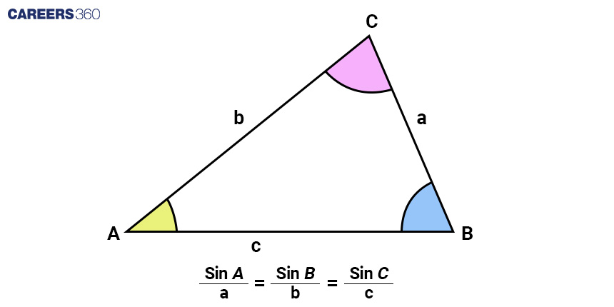
sin(A)/a = sin(B)/b = sin(C)/c
This law enables navigators to calculate unknown angles or sides of a triangle based on the known values of other angles and sides, a crucial skill for determining positions and angles on navigational charts.
Spherical Trigonometry
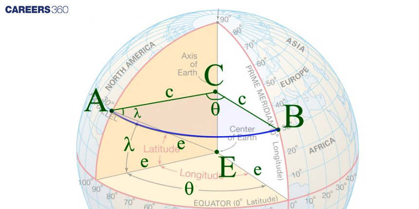
Spherical trigonometry, on the other hand, deals with problems in three-dimensional space, primarily in astronomy and navigation. It is particularly relevant when celestial observations are involved. The Earth's surface is approximately spherical, so spherical trigonometry is used to relate angles and distances on the Earth's curved surface.
Consider the challenge of determining latitude and longitude using celestial observations. The angle between the North Star (Polaris) and the horizon at the observer's location is known as the celestial latitude (L). Similarly, the angle between the observer, the zenith (the point directly above the observer), and a celestial object is called the celestial altitude (h). Spherical trigonometry is employed to relate these angles to the observer's latitude (ϕ), the object's declination (δ), and the observer's longitude (λ).
Here's a mathematical representation of this relationship:
sin(L )= sin(ϕ)⋅sin(δ) + cos(ϕ)⋅cos(δ)⋅cos(h)
Solving for latitude (ϕ):
ϕ = arcsin(sin(L) − sin(δ)⋅sin(h))
This formula allows navigators to determine their latitude using celestial observations. Further calculations, often involving time and observations of different celestial objects, are employed to calculate longitude.
Celestial Navigation
Celestial navigation, one of the most sophisticated applications of trigonometry in navigation, involves using the positions of celestial objects, such as the sun, the moon, planets, and stars, to determine one's position on the Earth's surface. This method relies on the principles of spherical trigonometry to convert celestial observations into latitude and longitude.
The process begins with measuring the angle between the celestial object and the horizon. This angle, known as the celestial altitude, is crucial for determining the object's declination (angular distance north or south of the celestial equator) and the observer's latitude. By combining multiple observations and applying trigonometric principles, navigators can pinpoint their position with impressive accuracy.
Celestial navigation played a pivotal role in the age of exploration, allowing sailors to venture into open waters and discover new lands. It enabled explorers like Christopher Columbus and Ferdinand Magellan to undertake ambitious voyages and expand the known boundaries of the world.
Confused between CGPA and Percentage?
Get your results instantly with our calculator!
Practical Applications of Trigonometry in Navigation
Distance and Speed Calculation
Trigonometry is the foundation for calculating distances between two points on the Earth's surface, a critical task when sailing the high seas. The haversine formula is a classic example of trigonometric calculation used to determine the great-circle distance between two locations given their latitudes and longitudes. This formula takes into account the Earth's curvature, providing a more accurate distance measurement for navigational purposes.
a = sin2(Δlat/2) + cos(lat1).cos(lat2).sin2(Δlon/2)
c = 2.atan 2(√a,√(1-a))
d = R.c
Where
a is the square of half the chord length between the points.
c is the angular distance in radians.
d is the distance over the Earth's surface.
Δlat and Δlon are the differences in latitude and longitude between the two points.
lat1 and lat2 are the latitudes of the two points.
R is the radius of the Earth.
This formula enables sailors to calculate distances with precision, allowing them to plan voyages and estimate travel times accurately.
Course and Bearing
Trigonometry also plays a vital role in determining the course or bearing (the direction to steer) needed to reach a specific destination. When sailing, knowing the direction to steer is essential for reaching the intended destination efficiently.
One of the key trigonometric relationships used for this purpose is the law of tangents:
tan(C) = sin(Δlon)/{cos(lat1).tan(lat2)-sin(lat1).cos(Δlon)}
Where
C is initial course or bearing
lon is the difference in longitude between starting and destination points
Lat1 and lat2 are the latitudes of starting and destination points.
By applying this formula, sailors can calculate the initial course to steer to reach their desired destination, taking into account the Earth's curvature.
Great Circle Routes
When planning long-distance voyages, sailors often opt for great circle routes, which are the shortest paths between two points on the Earth's surface. These paths follow the arc of a great circle, representing the shortest distance over a sphere.
Trigonometry comes into play when determining the initial course along a great circle route. Navigators calculate the initial course using the law of sines or the law of tangents, ensuring that the vessel follows the most efficient route.
The law of sines, as mentioned earlier, relates the angles and sides of a spherical triangle and is particularly useful for calculating initial courses along great circle routes.
Also check - Trigonometry For NEET: Concepts And Paper Analysis
Dead Reckoning
Dead reckoning is a method of estimating a ship's current position based on its last known position, course, and speed. While not as precise as celestial or GPS-based navigation, dead reckoning serves as a valuable backup method and is especially useful during adverse weather conditions or equipment failures.
Trigonometry is employed in dead reckoning to update the ship's position as it progresses along its intended route. By calculating the distance travelled and the direction steered since the last known position, mariners can estimate their current location.
Electronic Navigation and Trigonometry
In the modern era, electronic navigation tools like GPS have reduced the reliance on traditional trigonometric methods. GPS provides highly accurate position data based on signals from satellites. However, understanding trigonometry remains valuable for cross-checking GPS data and for backup navigation methods in case of equipment failure or signal loss.
Ship Design and Sail Optimisation
As navigational accuracy improved, so did the design of ships and sails. Trigonometry played a crucial role in optimising sail designs, allowing vessels to harness the power of the wind more effectively. Sail shapes and angles were adjusted based on trigonometric principles to achieve greater propulsion, enabling ships to sail faster and more efficiently.
